1. Overview
2. Economy
3. Belfast
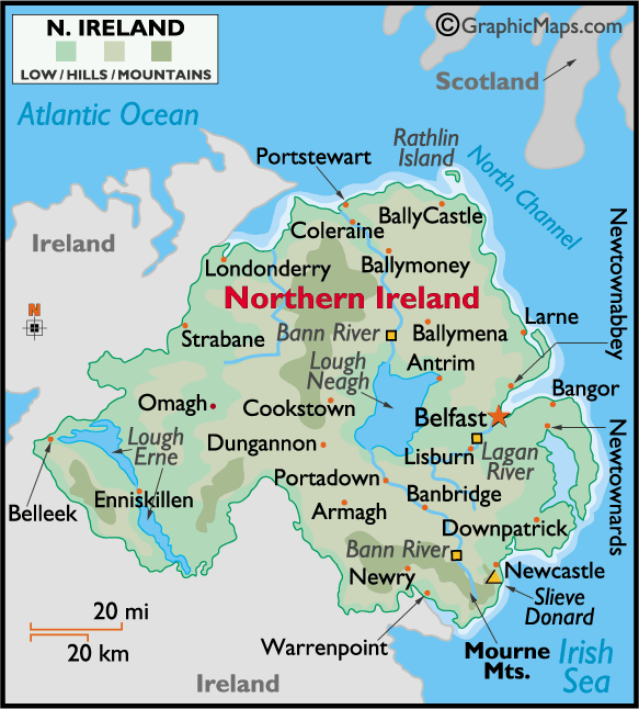
 Northern
Ireland (14,160 sq km) is much smaller than Hungary, in fact it is smaller than
Bács-megye. At its nearest point, Northern Ireland’s north-eastern coast is
separated from Scotland by a stretch of water - the North Channel - only 21 km
(13 miles) wide. It includes Rathlin Island in the North Channel and several
smaller offshore islands (
Northern
Ireland (14,160 sq km) is much smaller than Hungary, in fact it is smaller than
Bács-megye. At its nearest point, Northern Ireland’s north-eastern coast is
separated from Scotland by a stretch of water - the North Channel - only 21 km
(13 miles) wide. It includes Rathlin Island in the North Channel and several
smaller offshore islands (![]() ).
On the south and west it has a 488 km (303 mile) border with the Irish Republic,
forming the UK’s only land boundary with another Member State of the European
Union. On the south-east Northern Ireland is bounded by the Irish Sea.
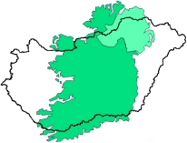
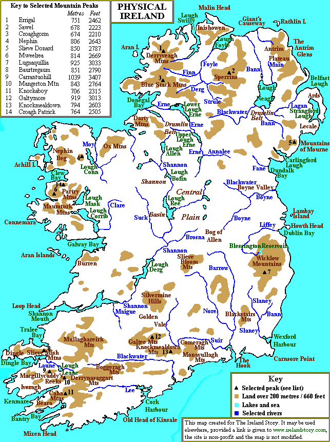
The centrepiece of Northern Ireland's geography is Lough Neagh,
(392 km² - two third
of the area of the lake Balaton) the largest freshwater lake in the British Isles.
There are three major upland (hilly) territories: the Sperrin Mountains with extensive gold deposits,
the Antrim Plateau and the Mourne Mountains (
).
On the south and west it has a 488 km (303 mile) border with the Irish Republic,
forming the UK’s only land boundary with another Member State of the European
Union. On the south-east Northern Ireland is bounded by the Irish Sea.
The centrepiece of Northern Ireland's geography is Lough Neagh,
(392 km² - two third
of the area of the lake Balaton) the largest freshwater lake in the British Isles.
There are three major upland (hilly) territories: the Sperrin Mountains with extensive gold deposits,
the Antrim Plateau and the Mourne Mountains (![]() ). The
Mourne
Mountains are the most picturesque mountain district in Ireland. The
). The
Mourne
Mountains are the most picturesque mountain district in Ireland. The
|
Many people use other names for Northern Ireland, depending on their point of view:
Unionist/LoyalistUlster - to suggest that Northern Ireland has an older ancestry that predates its founding in 1921. The Province - to link to the historic Irish province of Ulster, with its mythology. It also refers to the fact that NI is a province of the UK.
Nationalist/RepublicanNorth of Ireland - to link Northern Ireland to the rest of the island, by describing it as being in the 'north of Ireland'. The Six Counties - used by republicans e.g. Sinn Féin, which avoids using the name given by the British-enacted Government of Ireland Act, 1920. The Occupied Six Counties or British Occupied Ireland meanwhile The Republic of Ireland is referred as being ‘The Free State’ |
twelve peaks include Slieve Donard, which at 850 m is Northern Ireland's highest mountain. The main rivers - River Bann, River Foyle and River Blackwater -
form extensive fertile lowlands, with excellent arable land
on the North and East. The hilly parts of the country suitable largely for
animal husbandry. The climate is maritime
influenced by the Gulf Stream. Although the seasons
are distinct, they are considerably less pronounced than in interior Europe.
The weather is unpredictable at all times of the
year; wetter in the west than the east, although cloud cover is persistent
across the region. Average maximum
temperatures are around 6 °C
in winter and 18 °C
in summer.
About half of Northern Ireland’s 1.7 million population live in the eastern coastal region, at the centre of which is the capital, Belfast. Most of the population of Northern Ireland is at least nominally Christian. Around 45% of the Northern Irish population is Protestant, (Presbyterian, Church of Ireland, Methodist and other Protestant denominations), 40% of the population is Roman Catholic. A majority of Protestants feel a strong connection with the United Kingdom and wish for Northern Ireland to remain a part of it. Many Catholics desire a greater connection with the Republic of Ireland, however about a quater of Northern Irish Catholics support Northern Ireland remaining a part of the UK. The two opposing views of British unionism and Irish nationalism are linked to deeper cultural divisions. Unionists are predominantly Protestant and often descendants of mainly Scottish, English, Welsh settlers, whilst the Nationalists are predominantly Catholic and usually descend from the population predating the settlement (better to say colonisation by the Scottish, Welsh and Ennglish at the beginnig of the 17th century).
Northern Ireland has the smallest economy of any of the twelve of the United Kingdom
(London, 9 in England, Scotland, Wales and NI), at €37.3 billion
(![]() €128
billion). This is partly because Northern Ireland has the smallest population. Northern Ireland has a greater GDP per capita than both North East England and Wales. Throughout the 1990s, the Northern Irish economy grew faster than did the economy of the rest of the UK, due in part to the rapid growth of the Irish economy.
However this pace slowed down in the early years of the new millennium, in 2005, the Northern Irish economy is estimated to have grown by 3.2%,
almost twice as fast as the UK as a whole. Unemployment
in Northern Ireland has decreased significantly in recent years
from 17.2% in 1986 to the present 4.5%
(
€128
billion). This is partly because Northern Ireland has the smallest population. Northern Ireland has a greater GDP per capita than both North East England and Wales. Throughout the 1990s, the Northern Irish economy grew faster than did the economy of the rest of the UK, due in part to the rapid growth of the Irish economy.
However this pace slowed down in the early years of the new millennium, in 2005, the Northern Irish economy is estimated to have grown by 3.2%,
almost twice as fast as the UK as a whole. Unemployment
in Northern Ireland has decreased significantly in recent years
from 17.2% in 1986 to the present 4.5%
(![]() 6.1%).
6.1%).
Agriculture is producing about the 2.5% of the GDP that is much higher than the UK average (1%). The production is heavily mechanised, thanks to high labour costs and heavy capital investment, and as in the rest of the United Kingdom, livestock and dairy account for the majority of agricultural output.
Machinery and equipment manufacturing, food processing, and textile and electronics manufacturing are the leading industries. Other industries such as papermaking, furniture manufacturing, aerospace and shipbuilding are also important. The production is concentrated mostly in the eastern parts of Northern Ireland. The contribution of the industry sector to the GDP has remained almost unchanged over the past five years, after a period of steep manufacturing growth between 1998 and 2001.
As with all developed economies, services account for the majority of employment and output. Services account for almost 70% of economic output, and 78% of employees. Despite the negative image of Northern Ireland held in many foreign countries, on account of the Troubles, tourism is an important part of the Northern Irish economy. In 2004, tourism revenue rose over 1% of the local economy,
|
'Irish Big Ben' |

Capital (283,000; 2002), of Northern Ireland. It is on Belfast Lough, an inlet of the North Channel of the Irish Sea, and at the mouth of the Lagan River. The harbour, 8.5 mi (13.7 km) long, is navigable to the largest ships. The great shipyards of the Harland and Wolff Company in Belfast have built some of the world's largest ocean liners. The city is also the centre of the Irish linen industry. Belfast was founded in 1177 when a castle in defense of a ford over the Lagan was built, but the present city is a product of the Industrial Revolution. French Huguenots, coming there after the revocation of the Edict of Nantes (1685), they greatly stimulated the growth of the town's linen industry. Belfast and the surrounding country were subjected to heavy air raids in 1941. Serious rioting between Catholics and Protestants, who live in distinct sections of the city, has scarred Belfast many times since the 19th century. After 1969, subsequent to the use of British troops to support the police, the use of guns and bombs escalated. The city suffers from high unemployment, and its population decreased markedly due to the violence and the planned economic development of outlying areas. The Parliament House of Northern Ireland is at Stormont, a suburb.
sources:
National Statistics, UK 2002, The Official Yearbook of Great Britain and Northern Ireland
Wikipedia, Northern Ireland
Microsoft Encarta
1. Photo of Albert Memorial Clock © Gerry Lynch 2005
2. Belfast: Wikipedia The Free Encyclopedia under GNU Free Documentation Licence.