Physical and human Geography of the United Kingdom
1. Overview
3. Area
4. Climate
5. Terrain
9. Where are Britain’s Overseas Territories?
11. What are ‘GMT’ and ‘British Summertime’?
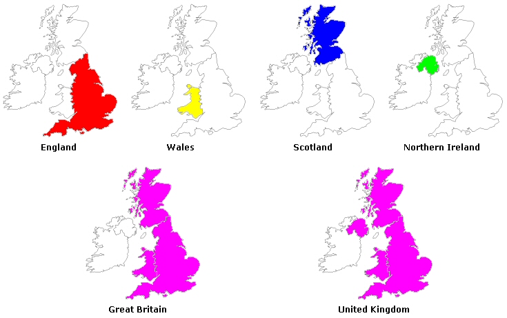
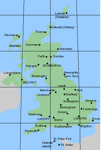
The United Kingdom comprises the island of Great Britain (England, Scotland and Wales) and the northeastern one-sixth of the island of Ireland (Northern Ireland), and several smaller islands. Great Britain is the world’s eighth-largest island. The name Britain is sometimes used to refer to the United Kingdom as a whole, while “Great Britain” is used only in reference to England, Wales, and Scotland. The UK lies between the North Atlantic Ocean and the North Sea, and comes within 35 km (22 miles) of the northwest coast of France, from which it is separated by the English Channel. Northern Ireland shares a 360 km international land boundary with the Republic of Ireland. England, occupying most of southern Great Britain, includes the Isles of Scilly off the southwest coast and the Isle of Wight off the southern coast. Scotland, occupying northern Great Britain, includes the Orkney and Shetland islands off the northern coast and the Hebrides off the northwestern coast. Wales lies west of England and includes the island of Anglesey to the northwest. At its widest the United Kingdom is 300 miles (500 km) across. From the northern tip of Scotland to the southern coast of England, it is about 600 miles (1,000 km). No part is more than 75 miles (120 km) from the sea. The capital and largest city is London. The Isle of Man and the Channel Islands are direct dependencies of the British Crown, and not part of the United Kingdom. They have their own legislatures and legal systems; the British government is responsible only for their external affairs and defence.
|
The Channel Islands (Guernsey and Jersey) were part of the Duchy of Normandy in the 10th and 11th centuries and remained subject to the English Crown after the loss of mainland Normandy to the French in 1204. |
The Isle of Man was under the nominal sovereignty of Norway until 1266, and eventually came under the direct administration of the British Crown in 1765, when it was bought for £70,000. Its parliament, ‘Tynwald’, was established more than 1,000 years ago and is the oldest legislature in continuous existence in the world. |
![]()
|
|
Llanfairpwllgwyngyllgogerychwyrndrobwllllantysiliogogogoch (58 letters) - this is the whole name of Llanfairpwllgwyngyll (on the map). It is a village on the island of Anglesey in Wales, situated close to the Menai Bridge. It is best known for having the longest officially recognised place name in the United Kingdom (see station platform to the left). Many of the people are very proud of their little town and its name. If you ask one of them to pronounce the name of their town, they are usually happy to oblige. However it is not the longest town name in the world. Thailand has a town whose name has 163 letters: Krungthepmahanakornamornratanakosinmahintarayutthaya- mahadilokphopnopparatrajathaniburiromudomrajaniwesmahasa- tharnamornphimarnavatarnsathitsakkattiyavisanukamprasit |
|
244,820 sq km ( |
|||||||||||||||||||||||||||||||||||||
|
Comparative area: |
|
||||||||||||||||||||||||||||||||||||
|
Despite its reputation for grey skies (more than one-half of the days are overcast) and rain, the climate in Britain is generally mild and temperate - significantly warmer than some other locations at similar latitude due to the warming influence of the Gulf Stream. In general, the south is warmer and drier than the north. The weather from day to day is mainly influenced by winds moving eastwards across the Atlantic. Although the weather changes frequently, the temperature is subject to few extremes - it is rarely above 32°C or below -10°C. Rain is fairly well distributed throughout the year, but, on average, March to June are the driest months and September to January the wettest. If you visit the mountainous areas of the west and north you can expect more rainfall than in central parts of Britain. Average annual rainfall varies from over 3,000 mm (120 inches) in the Scottish Highlands down to 553 mm (21.8 in) in Cambridge. During May, June and July - the months of longest daylight - the mean daily duration of sunshine varies from five hours in northern Scotland to eight hours in the Isle of Wight on the south coast. November, December and January have the least sunshine - only an hour a day in northern Scotland or two hours a day on the south coast of England. |
|||||||||||||||||||||||||||||||||||||
|
The highest mountains are in...
The largest lakes are in...
The longest rivers are in...
The longest river in the UK is the River Severn (354 km) which flows through both Wales and England. As a result of its industrial history, the United Kingdom has an extensive system of canals, mostly built in the early years of the Industrial Revolution, before the rise of competition from the railways. The United Kingdom also has numerous dams and reservoirs to store water for drinking and industry. |
|||||||||||||||||||||||||||||||||||||
|
Elevation extremes: |
highest point: Ben Nevis 1,343 m
lowest point: The Fens -4 m (lower dot) |
||||||||||||||||||||||||||||||||||||
|
About 75 per cent of the land area is suitable for
agriculture. Around 40 per cent of this is suitable for arable farming,
concentrated mainly in eastern and south-central England, and eastern
Scotland. The majority of land is under grass and given over to livestock
grazing. Most sheep and cattle are reared in the Scottish Highlands, and on
the hill and moorland areas of Wales, Northern Ireland, and northern and
south-western England.
In contrast, Britain has the richest energy resources of the EU - including large deposits of coal, mined for more than 300 years (however coal production is down to one fifth compared to its peak at the beginning of the 20th century.), and oil and natural gas, both primarily found in the British sector of the North Sea, off eastern Scotland and eastern England respectively. Oil was first discovered in 1969 and production began in 1975; by 1980, 15 fields were producing almost all of Britain’s requirements. In the mid-1990s over 100 fields were in production, and Britain was within the world’s top-ten oil producers (now the 13th). Production of natural gas began in 1967; today Britain is the world’s fourth-largest gas producer. |
National Parks in the United Kingdom
Ten National Parks were created in England and Wales at during the 1950’s; three in Wales and seven in England. The establishment of National Parks in Scotland (for long one of only four countries in the world without) has just finished. Altogether they cover more than 10% of the land in the United Kingdom. National Parks aim both to protect the outstanding countryside within their boundaries and to provide opportunities for outside recreation for their many thousands of visitors each year. The largest Park is The Cairngorms N.P. in Scotland (3,800 sq km). The three National Parks in Wales account for about the 20 per cent of the total land area. They are so called "working" or “lived in” landscapes, where people and nature co-exist.
 England
[1] Dartmoor
[2] Exmoor
[3] Lake District
[4] North York Moors
[5] Northumberland
[6] Peak District
[7] Yorkshire Dales
[8] The Broads*
[9] The New Forest, 2005
[10] South Downs**
Wales
[11] Snowdonia
[12] Brecon Beacons
[13] Pembrokeshire Coast
Scotland
[14] Cairngorms National Park, 2003
[15] Loch Lomond, 2002
In October 2002 it was announced that the Mournes is to become Northern Ireland's first national park. Still in process...
* Officially The Broads is not a N.P. but The Norfolk and Suffolk Broads Act of 1988 gave it a level of protection similar to a national park.
** The designation process is expected to take another two to three years.
At the April 2001 census, the United Kingdom's population was 58,789,194 (This has risen to 60,441,457 according to July 2005 estimates) - the third-largest in the European Union (behind Germany and France) and the 22st-largest in the world. The total population of England is estimated at 49.1 million (84%), Wales is estimated at 2.9 million (5%), Scotland (8%) at 5.1 million and Northern Ireland at 1.7 million (3%) people. Its overall population density is one of the highest in the world. Almost one-third of the population lives in England's prosperous and fertile southeast and is predominantly urban and suburban - with about 7.2 million in the capital of London. England has the highest population density and Scotland has the lowest. In 2001 there were 61 cities in the UK: 49 in England, five in Scotland, four in Wales and three in Northern Ireland. City status is a mark of distinction granted by the personal Command of the Sovereign, on the advice of his or her Ministers.
The population of Britain’s major cities is as follows (2001 census):
|
England London 7,172,091 Birmingham 970,892 Liverpool 469,017 Leeds 443,247 Sheffield 439,866 Bristol 420,556 Manchester 394,269
|
Scotland Glasgow 629,501 Edinburgh 430,082 Aberdeen 184,788 Dundee 154,674
|
|
Wales Cardiff 305,340 Swansea 225,000 Newport 139,500 |
Northern Ireland Belfast 276,459 Derry 90,736
|
|
Age structure: |
0-14 years: 17.7% ( |
|
Population growth rate: |
0.28% ( |
|
Life expectancy at birth: |
total population: 78.4 years ( |
|
Ethnic groups: |
2001 census:
|
|
Religions: |
The United Kingdom has one of the lowest levels of worship in the world, with less than 8% of people actually attending any form of worship on a regular basis (of whom the majority are of middle-aged and older generations). The main religion in the UK is Christianity, first introduced by the Romans. The Church of England is the officially established Christian church in England. It was established in 597 by Augustine of Canterbury on behalf of Pope Gregory I, but split from Rome in 1534 during the reign of Henry VIII of England. The Church of England is a state church, and its bishops sit in the House of Lords. The British monarch is required to be a member of the Church of England under the Act of Settlement 1701 and is the Supreme Governor. The Church of England is based at Canterbury Cathedral and the Archbishop of Canterbury is the senior clergyman. The Church in Wales was disestablished in the 1920s, although remains in the Anglican community. The Church of Scotland (known informally as The Kirk) is the national church of Scotland. It is a Presbyterian church and is not subject to state control. The British monarch is an ordinary member, although the monarch is required to swear an oath to "defend the security" of the Church at their coronation. Splits in the Church since the reformation have led to the creation of various other Presbyterian churches in Scotland. The Catholic Church in Great Britain is the second largest denomination of Christianity in the UK. Although after the reformation, strict laws were passed against Catholics; these were removed by the Catholic Emancipation laws in the 1850s. In the latter half of the 20th century, large scale
immigration from the Commonwealth countries has led to the introduction of
other religions that are popular amongst ethnic minorities. This has
included religions such as Islam, Hinduism, Sikhism
and
Buddhism.
|
|
Languages: |
English Welsh (610,000 - about 26% of the population of Wales) Scottish form of Gaelic (about 60,000 in Scotland) Irish form of Gaelic (about 160,000 in Northern Ireland) |
Where are Britain’s Overseas Territories?
There are 14 British overseas territories, mostly with considerable self-government, with a legislature and a civil service. Britain has general responsibility for their defence, internal security and foreign relations. British policy is to give independence to those overseas territories that want it, and not to force it on those which do not.
The territories are: Anguilla; Bermuda; British Antarctic Territory; British Indian Ocean Territory; British Virgin Islands; Cayman Islands; Falkland Islands; Gibraltar; Montserrat; Pitcairn Islands (Ducie, Henderson and Oeno); South Georgia and the South Sandwich Islands; St Helena; St Helena Dependencies (Ascension and Tristan da Cunha); and the Turks and Caicos Islands.
In July 1997, the 99-year lease which China granted Britain for 92 per cent of Hong Kong under the Second Convention of Peking in 1898 expired. Hong Kong was returned to the People’s Republic of China under the terms of the Sino-British Joint Declaration of 1984. Under this agreement Hong Kong is able to maintain a high degree of autonomy, including independent finances, for 50 years as a Special Administrative Region of China.
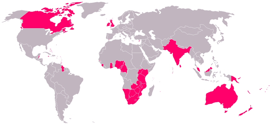
The Commonwealth is a voluntary
association of independent states which originated in the progressive
dismantling of the British Empire after 1945. It works to promote such
principles as democracy, economic development and international understanding,
mainly through intergovernmental consultations and the Commonwealth
organisations. There are no legal or constitutional obligations involved in
membership.
The Queen is recognised as head of the Commonwealth; she is also head of State
in 16 member countries. These are: United Kingdom, Antigua and Barbuda,
Australia, The Bahamas, Barbados, Belize, Canada, Grenada, Jamaica, New Zealand,
Papua New Guinea, St. Kitts and Nevis, St. Lucia, St. Vincent and the
Grenadines, Solomon Islands, and Tuvalu.
The following members of the Commonwealth are republics, with a president as
head of State: Bangladesh, Botswana, Cameroon, Cyprus, Dominica, Fiji, The
Gambia, Ghana, Guyana, India, Kenya, Kiribati, Malawi, Maldives, Malta,
Mauritius, Mozambique, Namibia, Nauru, Nigeria, Pakistan, Seychelles, Sierra
Leone, Singapore, South Africa,
Sri Lanka, Tanzania, Trinidad and Tobago, Uganda, Vanuatu, Zambia and Zimbabwe.
Of the remaining members of the Commonwealth, Brunei is a sultanate and Lesotho,
Malaysia, Swaziland and Tonga have their own monarchs. Western Samoa has a
constitutional monarch, appointed for life.
What are ‘GMT’ and ‘British Summertime’?
GMT or ‘Greenwich Mean Time’ is the local time of the 0 degree meridian that passes through Greenwich in London, from which the standard times of different areas of the globe are calculated. Thus it is the standard time for Britain, and a basis for other time zones in the world. Summer time or BST (British Summer Time) runs from the end of March to the end of October (the last Sunday in each month), when clocks are advanced one hour ahead of GMT to gain maximum use of daylight hours.
sources:
100 Questions Answered; Foreign & Commonwealth Office, London
National Statistics, UK 2002, The Official Yearbook of Great Britain and Northern Ireland
Wikipedia, Geography of the United Kingdom
Wikipedia, Demographics of the United Kingdom
Microsoft Encarta 2004 Encyclopedia Plus
National Parks in England, Wales & Scotland
Terrain: extracted from Wikipedia The Free Encyclopedia under GNU Free Documentation Licence.
Religion: extracted from Wikipedia The Free Encyclopedia under GNU Free Documentation Licence.
Physical map of the British Isles: Permission is granted to copy, distribute and modify under GNU FD Licence.
Photo of Llanfairpwllgwyngyll station platform © Paul Lloyd 2004


 The
physical geography of the UK varies greatly. It includes the chalk cliffs of
Kent [1] and Dorset [2], the rolling hills and fields of southeast England,
the granite cliffs of Cornwall [3], the mountains of Wales [4], the uplands
of the Peak District [5] and the Pennines [6], the lakes and mountains of
Cumbria [7], the Scottish lowlands [8], highlands [9] and islands, and the
fields, lakes and mountains of Northern Ireland [10]. The country can be
roughly divided into highland and lowland along the Tees-Exe line (on the
map) that links the mouth of the River Tees, the north east of England with
the mouth of the River Exe in Devon, the south west.
The
physical geography of the UK varies greatly. It includes the chalk cliffs of
Kent [1] and Dorset [2], the rolling hills and fields of southeast England,
the granite cliffs of Cornwall [3], the mountains of Wales [4], the uplands
of the Peak District [5] and the Pennines [6], the lakes and mountains of
Cumbria [7], the Scottish lowlands [8], highlands [9] and islands, and the
fields, lakes and mountains of Northern Ireland [10]. The country can be
roughly divided into highland and lowland along the Tees-Exe line (on the
map) that links the mouth of the River Tees, the north east of England with
the mouth of the River Exe in Devon, the south west.
 Britain has relatively
few mineral resources; natural gas and oil dominates the production over
construction (gypsum, clay, etc.) and industrial (salt, potash, etc.)
minerals. The coal deposits of north-central England, Wales,
and Scotland, and the iron ore deposits of the Pennines area played an
important role in Britain’s development as the world’s first industrial
nation. Since the end of World War II the iron-ore and tin-mining industries
have been declined by the exhaustion of reserves. The last surviving Cornish
tin mine continued a 3,000-year-old tradition, dating back to the
Phoenicians, until its closure in 1998.
Britain has relatively
few mineral resources; natural gas and oil dominates the production over
construction (gypsum, clay, etc.) and industrial (salt, potash, etc.)
minerals. The coal deposits of north-central England, Wales,
and Scotland, and the iron ore deposits of the Pennines area played an
important role in Britain’s development as the world’s first industrial
nation. Since the end of World War II the iron-ore and tin-mining industries
have been declined by the exhaustion of reserves. The last surviving Cornish
tin mine continued a 3,000-year-old tradition, dating back to the
Phoenicians, until its closure in 1998. 
