1. Overview
2. London
|
The Channel Tunnel is 50 km long rail tunnel beneath the English Channel, of which 39 km are undersea. The average depth is 45 m underneath the seabed. It opened for business in late 1994, offering three principal services: a shuttle for vehicles, Eurostar passenger service linking London with Paris and Brussels, and through freight trains. In 2004, 7,276,675 passengers travelled through the tunnel on Eurostar. A journey through the tunnel lasts about 20 minutes. |
England is bordered to the north by Scotland and to the
west by Wales. England is divided from France only by a 38 km sea gap, The English Channel.
England (130,410 sq km) is
1.4 times larger than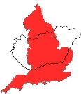 Hungary. England is a country of mostly low hills and
plains with a 3,200-km (2,000-mile) coastline cut into by bays, coves and
estuaries. These natural harbours, easily accessible to deep-water shipping,
were decisive in the economic development and imperial expansion of England. The
terrain of England is very diverse relative to the size of the country (just
like that of Hungary).
Hungary. England is a country of mostly low hills and
plains with a 3,200-km (2,000-mile) coastline cut into by bays, coves and
estuaries. These natural harbours, easily accessible to deep-water shipping,
were decisive in the economic development and imperial expansion of England. The
terrain of England is very diverse relative to the size of the country (just
like that of Hungary).
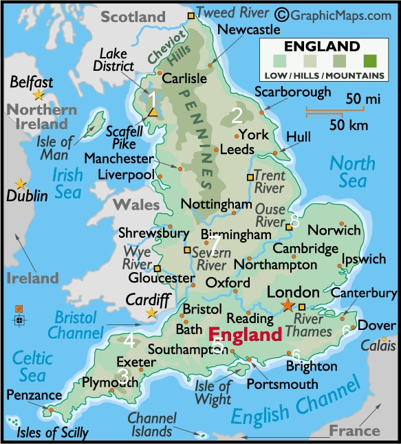
Upland regions in the north include the Pennine Chain (see map bellow), splitting northern
England into northwestern and north-eastern sectors; the Cumbrian mountains
[1], home of the Lake District, with the highest point in England, Scafell Pike
at 978 metres (3,209 ft); and the rugged landscape of the Yorkshire moors
(láp) [2].
(The South West’s highest point is on Dartmoor (rising to 621 metres, 2,038 ft)
[3], but there are other upland areas, such as Exmoor (520 metres, 1,706 ft)
[4]. Successive ranges of hills radiate in all directions from Salisbury Plain
[5] in southern England including the Downs [6] (on the picture:
Culver Down, Isle of Wight)
that are a series of chalk hills in south-eastern England, running down to the
sea. The South Downs reach the coast near Brighton, the North Downs) at Dover,
where they end in the famous white cliffs, which are
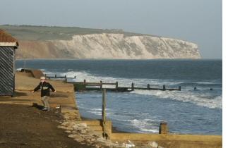 the first sight of
England for travellers by sea from continental Europe.
the first sight of
England for travellers by sea from continental Europe.
The land lying between the Welsh border and the southern end of the Pennines is
an extension of the rolling plain that occupies most of the rest of England. The
central region of England is known as the Midlands [7] (see
regions of England). The lowlands
(the flattest part of England) lie to the east of the Pennines and the
Midlands, running south from the Yorkshire Moors [2] and include the Fens [8], a
vast, marsh area
(mocsár) much of which has been drained for
agricultural use.
The sunniest parts of the country are along the south coast of England. The dullest parts are the mountainous areas. Rainfall in England varies widely. The Lake District is the wettest, with average annual totals exceeding 2,000 mm (this is comparable with that in the western Highlands of Scotland). The Pennines and the moors of south-west England are almost as wet. However, all of East Anglia, much of the Midlands, eastern and north-eastern England, and parts of the south-east receive less than 700 mm a year. Over England the mean annual temperature at low altitudes varies from about 8.5 °C to 11 °C, with the coasts of Cornwall having the warmest weather. Typically, it rains every third day in England, perhaps somewhat more often in winter, though long, dry spells occur in most years.
More than four-fifths of the total population of the United Kingdom live in England, with the greatest concentrations in London and the South East, South and West Yorkshire, Greater Manchester and Merseyside, the West Midlands, and adjoining towns in the North East on the rivers Tyne, Wear and Tees. Between 1851 and the end of the 20th century, the population of England almost trebled (megháromszorozódik) and the rise is expected to continue from 50.2 million people in 2001 to 53.7 million in 2021.
 London,
the capital of England and the United Kingdom lies
on both sides
of the Thames River.
Greater London
(2004 pop. 7,420,600), consists of the Corporation of the City
of London (with red on the picture), usually called the City, plus 32 boroughs.
The City is the old city of London and is the modern city's commercial centre (having
a resident population of under 9,000 but a daily working population of around
300,000);
it is also referred to as the “Square Mile” because of its area. Each of the
boroughs of Greater London elects a council.
London,
the capital of England and the United Kingdom lies
on both sides
of the Thames River.
Greater London
(2004 pop. 7,420,600), consists of the Corporation of the City
of London (with red on the picture), usually called the City, plus 32 boroughs.
The City is the old city of London and is the modern city's commercial centre (having
a resident population of under 9,000 but a daily working population of around
300,000);
it is also referred to as the “Square Mile” because of its area. Each of the
boroughs of Greater London elects a council.
The Greater London Council administered the larger London area until 1986, when it was abolished by the Thatcher government (an act of political revenge) , making London unique as a world metropolis without a central governing unit. In 1999 the Greater London Authority Act re-established a single local governing body for the Greater London area, consisting of an elected mayor and the London Assembly. When the GLA took up its powers in July 2000, four other administrative bodies for which it is responsible also came into being. These are the Metropolitan Police Authority; the London Fire and Emergency Planning Authority; Transport for London; and the London Development Agency, one of nine regional agencies covering the whole of England (see regions of England).
The best-known streets of London are Fleet Street, the Strand, Piccadilly, Whitehall, Pall Mall, Downing Street, and Lombard Street. Bond and Regent streets and Covent Garden are noted for their shops. Buckingham Palace is the royal family's London residence. Municipal parks include Hyde Park, Kensington Gardens, Regent's Park (which houses the London Zoo), and St. James's and Green parks. Museums include the British Museum, the Victoria and Albert Museum, the National Gallery, the Tate Gallery, and the Wallace Collection. London also has numerous art galleries and plays a major role in the international art scene. The British Library, one of the world's great reference resources, is located there. The city is rich in other artistic and cultural activities. Its approximately 100 theatre companies reflect the importance of drama, and it has several world-class orchestras, a well-known opera house, performance halls, and clubs. A replica of Shakespeare's Globe Theatre opened in 1997. The University of London is the largest in Great Britain. The state-owned BBC (British Broadcasting Company) is headquartered in London, and most of the country's national newspapers are published there. The New Scotland Yard, synonymous with criminal investigation, is located in the city. Sporting events draw large support from Londoners who follow cricket, soccer, and tennis. (See more details in the slidewhow...)
|
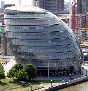
New Greater London Authority Building The new home for the Greater London Authority was built on a site between London Bridge and Tower Bridge on the south bank of the river Thames. This new landmark for the capital takes the form of a geometrically modified glass sphere standing 50 metres high with 21,700 square metres of floor space on ten storeys. In conventional terms the building has no front or back. It uses its radical shape to minimise its surface area—approximately 25% less than an equivalent rectangular building—and high-performance glass facing to ensure the best energy efficiency. A further ‘green’ feature is the use of cold ground water to air condition the building. The glass walls of the building symbolises 'transparency' of democracy and local government.
|
|
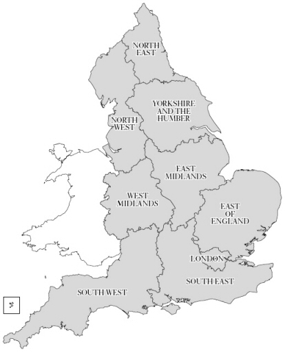 In contrast to Wales, Scotland
and Northern Ireland, England has no separate elected national body exclusively
responsible for its central administration. Instead a number of government
departments look after England’s day-to-day administrative affairs and a network
of nine
In contrast to Wales, Scotland
and Northern Ireland, England has no separate elected national body exclusively
responsible for its central administration. Instead a number of government
departments look after England’s day-to-day administrative affairs and a network
of nine